Follow Me on the CDT #12: BIg Sky Alternate
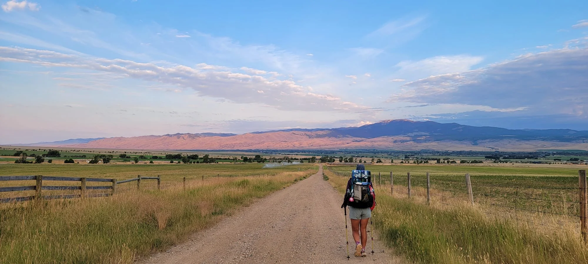
Dirt roads, paved roads, rocky trail, flat and dusty trail. In nearly 2,000 miles I thought I had walked every type of path there was. I was wrong. I was 6 miles down a paved, curated bike path. There were informational displays every mile complete with benches. Despite all the infrastructure we were surrounded by thick forest with a river down a steep bank. I could hear ATVs in the distance but otherwise we were alone. Only one cyclist had past us hours ago. This was the beginning of the Big Sky Alternate, also known as the Super Butte Cutoff.
The CDT redline continues west along the Idaho/Montana border and then cuts north into Butte. This alternate deviated 20 miles into Idaho to cut straight north into the town of West Yellowstone. For the first time on any long-distance trail, I was not relying on Far Out for navigation. There is no route for this alternate on the app. Instead I downloaded GPS files from previous hikers to use on Gaia. The biggest downside was losing the crowd sourced content I depended on. There are no water icons or recent updates, no trail conditions reported, no photos of sporadic waypoints. Seeing a line on a map does not translate to the paved path I was currently walking on.

I was bundled in wind pants and a puffy in the early morning. The days had been warm, but the mornings were still chilly. Jedi and I were headed into town to charge our phones over coffee, resupply, eat, and then walk 3 miles north of town to a National Forest campground. I was not exactly looking forward to West Yellowstone as my only other time in the area was during the height of tourist season (similar to now.) My memories were of hot, crowded, dusty streets with uninspired food and expensive ice cream. Walking through town before 9am was peaceful but the best spot we could find to sit was McDonalds. The cafes seemed specifically designed to keep folks from sitting longer than the 5 minutes it takes to serve coffee.
As far as town days go it was a relaxing one. I paid more for my 2-day resupply than I think reasonable, but in a town like West Yellowstone there are not options. At 5pm, we were on the walk out with a bag of fresh BBQ takeout. The benefit of established campgrounds is not the bathroom or water spigots, it's the trashcans. After a full BBQ dinner we can just throw away the trash - what a novelty!
The adventure of the alternate started in earnest the next morning. We made the decision to skip the long highway walk and hitch up to the trailhead. I wanted to include in the route the Sky Rim trail through the northern most edge of Yellowstone NP. The Sky Rim trail starts 20 miles north of West Yellowstone and heads west toward to the town of Big Sky. After only a few minutes standing with our thumbs out we got a hitch. Driving down the curvy highway, the shoulder disappearing relatively quickly, I was not regretful about the decision to hitch. At this point in the hike I no longer had the stamina to count every step. I needed to get to Canada before a certain date and if I had to speed up some sections I would rather it be a sucky highway walk.
The Sky Rim Trail might as well be part of the CDT. It had all the hallmark characteristics - back to back elevation gain and loss; exposed and dry; washed out path with no signage; and breathtaking views. It was a long, hot day hiking the rollercoaster of a ridge line. My limited capabilities on Gaia meant I had no idea I planned a 5,800 ft gain day. From the top of the ridge, we could see mountains unfolding 360 degrees around us. I was tired when we set up camp at a high point of the ridge but not too tired to appreciate the magical sunset from our unique vantage point.
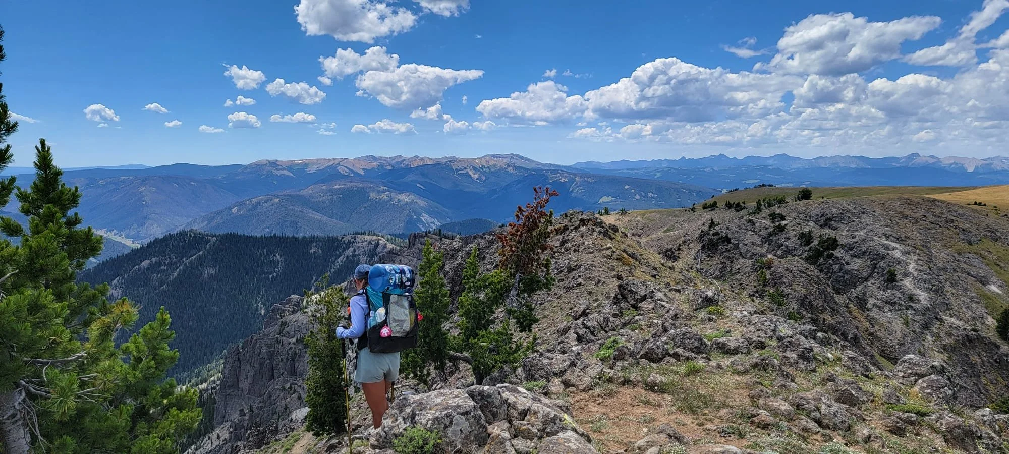
View from the Sky Rim Trail (Montana).
The next week would be a series of new mountain ranges broken up by stops into towns. First was the town of Big Sky, Montana. Easily my least favorite town of the trail. I had no idea such a town existed in the state of Montana. It a small town nestled in the mountains that mark the start of the Spanish Peaks. The views from the road are "pinch me" worthy. Because of this, the town is a sky resort nightmare. Hotels start at $400 a night and a simple pizza is $27. This was not a town meant for hikers and we quickly left after a short afternoon. Luckily it was only 1.5 days until the next stop in Ennis.

Spanish Peaks

Meadow of Wildflowers

Road walk into Ennis
To reach Ennis we climbed back into the Spanish Peaks and the endless meadows of wildflowers. Huckleberries were thriving along the cool, wet descents into the valleys. My only complaint was that it was over before we had a chance to appreciate it! After one day we were on the dirt road walk around Ennis Lake to the highway north of Ennis. Ennis, thankfully, has not gone the way of Big Sky and remains a true small town Montana residency. We were welcomed magnanimously into a trail angel's home where we spent not just one, but two nights.
It was during dinner our first night in Ennis that we realized we had less than a month left on trail. Taking the alternate cut off nearly 300 miles and was easily putting us ahead of my deadline. The realization came with freedom. We COULD zero here tomorrow! Our host offered up kayaks when we met her earlier and I declined thinking we needed to push on the next day. There was no longer a need to push on! Ennis was a top tier zero day featuring chores, naps, kayaking, and a grill out.

Leaving Ennis, the pattern continued - mountain range down into town. This time we were climbing across the Tobacco Root Mountains. These mountains couldn't be more different than the Spanish Peaks. For starters, there was not a single foot trail. The route across the mountains was solely dirt roads, ATV trails, and unkempt logging roads. The range was so vehicle accessible due to the gold and silver mines, now abandoned and in disrepair. It was spooky walking by cabins and machinery just left to rot in the trees. There were even metal bed frames and bathtubs left behind, not worth the hassle to remove. It was felt apocalyptic rather than the result of economic downturn. The roads led straight down into the not abandoned town of Whitehall, Montana. This would be our final stop on the alternate.

Abandoned mining cabin
Without the waypoints normally provided on Far Out, we were relying on word of mouth from other hikers about where to stay and eat. Not that there were many other hikers. Thus far we had met only 2 southbound thru hikers on the alternate. It was from them that we learned that the mayor of Whitehall has a soft spot for the hiking community and allows hikers to sleep free of charge in the old town ambulance bay. It was not until we were standing in front of the small, brick town hall building that it hit me that I had no concrete evidence that such a service was offered. There were no signs on the doors welcoming hikers, no posts online to double check, just a story from a hiker. Was I even positive that Whitehall was the town we had been discussing four days ago?
I went for a neutral tactic. I walked into the reception area and noted that the receptionist did not seem surprised to see people with packs but also did not offer up any greeting. "How can I help you?"
"We were hoping to spend the night in Whitehall and wanted to know if there were any location where we could pitch our tent?" I thought this did not sound as crazy as "can we sleep in here" if the answer turned out to be no.
"Oh, yes. This is the mayor's project. Follow me, she is right back here." The receptionist led us down a short hallway of two doors before pushing open a door into an ambulance day/large garage area. The space was filled with town Christmas decorations and boxes of files. Mayor Mary was indeed in there and gave us a tour around. There were carpets where we could blow up our pads, laundry, and even shower. It was a perfect stay. That night has a storm howled past overhead; we slept snug and dry under the town's tax receipts.
We rounded out the alternate with a hitch. The alternate connects to the red line on the eastern side of Butte, a straight shot down I-90. This means the walking path is flat, exposed, bustling dirt roads on the side of the interstate. I was alright for my hike to not include these 20 miles. We got a ride in the morning after picking up our last shoe packages from the post office. So with new kicks we stepped foot on the red line for the remaining 400 miles.